Mount Erebus - Antarctic Volcano
 The volcanic activity at
The
measurements monitors eruptive events of the volcano and the movement of lava
in and beneath the summit crater. MEVO sends its data to McMurdo
station and from there uses the McMurdo Internet to
forward it to scientists at the New Mexico Institute of Technology, to the
UNAVCO geodetic consortium, and to the larger geophysical community. (MEVO Website)
|
Shackleton Meets the Volcano |
|
The craters of |
Field studies on the volcano include analysis of lava bombs
and other forms of volcanic ejecta resulting from degassing
explosions in the lava lake. Other studies of
The inner crater is situated in the northeastern part of the
outer crater, and the lava lake and most eruptive activity are confined to its
northern half.
|
Mount Erebus supports a
broad glacier system, with, most ice sheets extending to the edges of the
island. Termini either form abrupt
cliffs which discharge ice to the marine waters of the Ross Sea on the north
and west, or they merge gently with the Of particular interest is the Erebus
Glacier Tongue, an elongate, serrate-edged lobe of ice that extends for
several kilometers into Erebus Bay of McMurdo
Sound, where most of it floats in water as much as 400 meters deep. The
glacier is 50 to 300 meters thick and lengthens about 160 meters a year. |
Lava issues from the northeastern edge of the crater and
flows slowly along a curved path before disappearing into a tunnel-like opening
at the south edge of the lake. Degassing explosions in the lake eject lava
bombs over the southern half of the inner crater and occasionally onto the
floor of the outer crater. Strong eruptions from the crater have thrown bombs
as high as 1000 meters and 700 meters laterally, onto the snow surface outside
both craters.
The crater topography is much more rugged than expected from
observations below, with some ridges more than 30 meters high, and with strange
formations of ice rising above fumerole areas--the
products of steam condensing and freezing immediately into some extraordinary
structures which rise here and there above the surface of the snowfield. 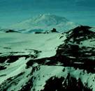
The lava lake may be a periodic, occurrence, depending on
the degree of volcanic and thermal activity in the crater. According to
geologist Robert Forbes, when he observed the crater during Operation Deep
Freeze in 1955, it contained only solid rock fragments. In 1974, a party of
|
Fire and Ice |
|
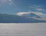
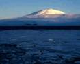
Of the volcanoes, only
Erebus remains active. At 3794 meters, It is almost always
observed with a cloud of vapor rising from its summit crater. Much eruptive and seismic
activity has been observed, including ejections of volcanic bombs as much as
8 meters across. At the summit, a
l00-meter-deep outer crater about 650 meters across contains a similarly deep
inner crater about 250 meters across, in which lies a lake of red, molten
lava. |