Trip Log and Notes

From: Cuesta Ridge Ophiolite Road Log

By: Paul G. Bauer (Cuesta College) and David H. Chipping

Click here to return to Hwy 41 drive to West Cuesta Ridge

In Morro Bay exit Hwy 41 to Atascadero
Set your odometer to 0.0 at the stop sign (Hwy 41 and Main St, Morro Bay)
5.8 miles - A tiny turnout. Use extreme caution as the cars are traveling very fast.
Ultramafic Rocks - serpentine green and brown (once dunite and harzburgite)
Dikes and Sills (originally diabase now rodingite)
6.3 miles - A better turnout.
6.5 miles - A better turnout.
6.9 miles - Turn right into the Cerro Alto Campground entrance.
9.6 miles - Turn right into a private road entrance. Devil's Gap just ahead!
11.7-12.0 miles - Sur-Nacimiento fault zone.
Gas & Food at Arco or 76 Union in Atascadero
15.5 miles - Go south on Hwy 101
25.6 miles - Exit into the Truck Brake Inspection lane. Continue to the stop sign.
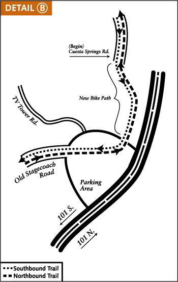
Reset Odometer to 0.0 miles - Go right toward Botanical Area

West Cuesta Ridge Road or TV Tower Road
0.0 miles - Follow the sign right to the Botanical Area
0.8 miles - Entering the Los Padres National Forest
1.3 miles - Stop in the middle of the road to look back at Cuesta Grade and more!
1.6 miles - An obvious(?) diabase dike on the right.
2.6 miles - fault(?) near the TV and radio transmitting towers.
Cuesta Ridge Botanical Area Panorama of the Sargent Cypress!
5.1 miles - exit the botanical area (end of Sargent Cypress trees)
Turnaround anywhere.
7.2 miles - sign reads '4 wheel drive only'
To the north along Cuesta Ridge is the Cerro Alto fire lookout.
NE across the valley (syncline) is Frog Pond Mountain (same rock sequence)

West Cuesta Ridge

Cuesta Grade Summit
TV Tower Road = West Cuesta Ridge Road

Truck Brake Inspection Exit
It's a lane not a semicircle!

Set Cuesta Ridge odometer to 0.0 here.

More Links and References
Don't do the Robert Stone hike! It's better to drive and enjoy the views!
Dual Sports Rides - Central Coast
Cuesta Ridge - Gorp
West Cuesta Ridge - SLOPOST
Cupressus sargentii - Jeff Bisbee photos
save the conifers around the world - Aboretum de Villardebelle
Frog Pond Mountain - BLM
Stagecoach Road photos
Types of Volcanic Rocks - USGS
Cuesta Ridge Ophiolite sequence - Geology
Bike Routes - Central Coast
Good biking trail information including 'Shooters Trail'
  
  Links Sally & Jim Trips  | Physics/Geology | SLO Sites | Dual Sport Riding | Local Hikes |

June 8, 2003 Back to Cuesta Ridge mainpage or California Drives