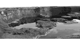
Dry Falls?
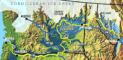
Map of the area including Channeled Scablands
Lake Missoula?
|
|
|
Dry Falls? |
Map of the area including Channeled Scablands |
Lake Missoula? |
They are located in Washington in the Columbia Basin. The Channeled Scablands are
located west of Lake Missoula. Lake Missoula used to cover a large, western area of Montana.
Scablands and Dry Falls located 7 miles southwest of Coulee City in N.E. Washington (3/4 of E.Wash.)
Were created following a massive collapse of an enormous ice-dam(glacier) holding back the waters of
what has been named "Glacier Lake Missoula". When it collapsed, it created a spectacular example of
"headward erosion". The falls are on the ancient course of the Columbia River. The river had been
diverted by encroaching glaciers. It is at its present day location by the ice retreating over time.
Weathering and erosion.
Channeled Scablands made 10,000 to 15,000 years ago. Lake Missoula flood = 17,200 B.P.
How it formed: Water cut underneath the glacial wall and the dam of ice collapsed over an expanse of
about 100 miles. The water rushed over the ice and onto the land with incredible force. The amount of
escaping water was equal to 10 times the discharge of all the Earth's rivers today. Water several
hundred feet deep flooded the region and ripped up hundreds of feet of soil and rock carrying it
inside the torrent of water westward toward the sea. The flood cut channels and carved landscape
now called the Channeled Scablands.
Click Here for Links I've reviewed.