Discover the High Plains of Colorado December 7, 2021 By
When most people think of Colorado, they think of mountains,
mesas, and rushing rivers. But nearly half of the state is made up of what is
called the High Plains, or what we Coloradans call the Eastern Plains, which
are a subregion and the westernmost point of the Great Plains.
Much of the land that lies east of the Rockies in Colorado
is often overlooked. And what most don’t realize is that this landscape has a
character all its own with some of the most diverse wildlife populations in the
state and unique recreational opportunities. Uncover the other half of the
state with a visit to these destinations on the High Plains of Colorado.
What
are the High Plains?
The High Plains of Colorado is an area bordered by Kansas to
the east and the foothills of the Rocky Mountains to the west, making up a part
of the Great Plains. The High Plains also extend throughout the Mid-west and up
north in states like Nebraska, Kansas, eastern Montana, southeastern Wyoming,
western Oklahoma, and South Dakota.
Landscape
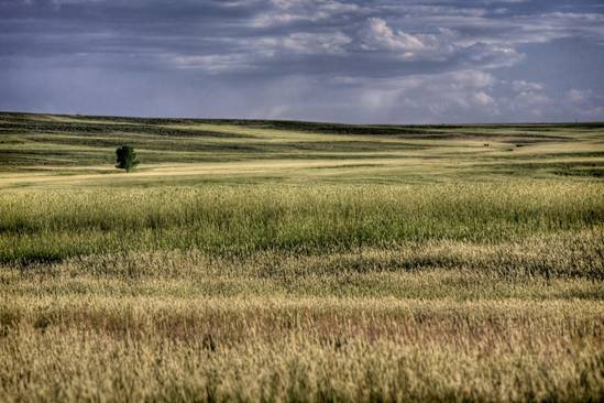
Short grass spreads throughout the High Plains of Colorado.
Photo by AJ Schroetlin.
The region is distinguished by mostly rolling plains,
divided by the South Platte River and Arkansas River valleys. While the land
appears scarce, there are many riparian forests along the major rivers,
canyons, buttes, and several natural lakes throughout the region. Seemingly
flat, the High Plains actually rise at roughly 3,400 feet along the eastern
border of Colorado and Kansas, to 7,500 feet east of the Denver Basin.
Much of the land is made up of silty and sandy soils,
minimal trees, and drought-resistant grama, and buffalo grasses, also known as
short grass. Two National Grasslands exist in Colorado and they are both on the
Eastern Plains. The Comanche National Grasslands near La Junta
and the Pawnee National Grasslands near Ault in northeastern Colorado.
Climate
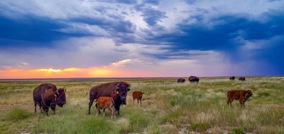 Herd of bison
with a stormy sky. Photo by Southern Plains Trust Facebook.
Herd of bison
with a stormy sky. Photo by Southern Plains Trust Facebook.
The climate is considered to be a cold semi-arid climate,
receiving up to 20 inches of rain annually. Because of its unique position in
higher elevation and its low precipitation, the High Plains can see a wide
range of extreme temperatures and weather. In addition to extreme temp
variances, it is also known for its highly intense winds that sweep down from
the Rockies.
Economy
While agriculture is the predominant industry out east in
Colorado, the recent development of wind farms in the High Plains is one of the
newest areas of economic development.
What
to see and do on the High Plains
From bird watching and hiking to historical landmarks and
pre-historic sites, there is plenty to see and do on the High Plains of
Colorado.
Birding
in Colorado
While Colorado is known for its big game of elk, moose, and
bear, it is also home to 100s of bird species that either make their home here
or migrate to warmer weather. The plains create the ideal environment for bird
watching.
The High Prairie and surrounding areas welcome over 400
species of birds including Warblers, Snow geese, Grosbeaks, Mountain Plovers,
and Buntings. They make their homes amongst the grasslands, craggy outcrops,
isolated ponds and rivers edged with cottonwoods and willows.
There are 20 birding trails on the Eastern Plains featuring
a variety of sites where you can view wildlife. Some trails include hiking or
walking paths where you can observe different wildlife and scenery.
There are several significant migrations that happen every
year, for which some of the communities of the Eastern Plains host festivals in
honor of these events.
Snow Goose Migration
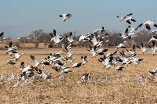
Migrating snow geese near Lamar, CO. Photo by: Jessica
Hughes
Every winter, along the snow goose trail near the town of Lamar
a swirl of snow geese, descend upon the High Plains of Colorado. This annual
migration lasts up to two weeks and can be witnessed within state wildlife
areas, local reservoirs, and area farms.
Beginning on the Great High Plains, a typical northern
migration can see 200,000+ snow geese returning from their wintering homes in
the south. As they make their way north, the snow geese stop at local
reservoirs and grasslands to feed. In celebration of this migration, the town
of Lamar hosts the annual High Plains Snow Goose Festival in early February.
Mountain Plover migration
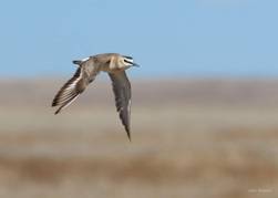
A mountain plover flying through the air at Adobe Creek
Reservoir. Photo by Julio Mulero.
Early April is when the Mountain Plover begins to arrive
along Colorado’s Eastern Plains. East of Pueblo is the Plover Trail, where the
attraction here is the short grass prairie and fallow fields grassland-loving
mountain plover to the snow plovers resting on the lakeshores.
In fact, the town of Karval, host an
annual Mountain Plover Festival each spring to celebrate this annual migration.
For more information about the birding trails and migrations, visit coloradobirdingtrail.com.
Historic
sites
The High Plains are steeped in history dating back to its
earliest settlers of the Ute, Cheyenne, Arapaho, Apache, and Shoshone tribes.
Today, visitors can visit these historic sites that helped shape our country
for future generations.
Bent’s Old Fort
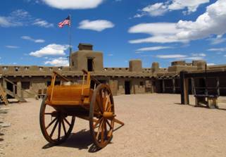
Bent’s Old Fort (replica) National Historic Site. Photo: Jasperdo
Bent’s Old Fort, located in La Junta, was an important stop
along the Santa Fe Trail and is one of southeastern Colorado’s biggest
attractions. The fort was originally built in 1833 and served as a retreat for
weary travelers.
Sand Creek Massacre National Historic Site
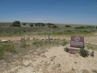
The Sand Creek Overlook at the Sand Creek Massacre Site.
Photo by Kelly Michals.
The memorial site, near Eads, honors the 200 Cheyenne and
Arapaho Indians who died here in 1864 when U.S. soldiers attacked their camp.
This single event is known to have changed the Great Plains forever. Visitors
will find a small visitor center, interpretive signs, and monuments located
from a vantage point overlooking the massacre site.
Camp Amache Relocation Center

Replica of a cell block at Camp Amache. Photo by Jessica
Hughes.
Located near the small town of Granada is the Camp Amache
Relocation Center. Set out on the High Plains, it was built to be hidden from
the rest of the world. Originally built to be hidden from the rest of the
world, Camp Amache was one of ten relocation centers the U.S. government built
to house the internment of Japanese Americans during World War II.
Over the two years, it was open, it saw 10,000 people come
through, with 7,500 internees at its height, making it at one point the
tenth-largest city in Colorado. What remains today at this national historic
landmark are only a few remnants including a water tank, the original concrete
foundations, guard watchtowers, and a cemetery.
Santa Fe Trail route
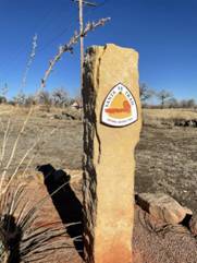
A Santa Fe Trail marker near Lamar, CO. Photo by Jessica
Hughes.
The portion of the 900-mile Santa Fe Trail that stretched
from Missouri to Santa, Fe New Mexico was called the Mountain Branch of the
Santa Fe Trail. The route rant through the southeastern part of the state, from
Trinidad to Holly, on the Colorado/Kansas border.
Historic land markers highlight the old stops along the
route in places like Boggsville, Bent’s Old Fort, Granada, Holly, Lamar, La
Junta, and so many more. Keep your eye out for the designated signs and the old
wagon ruts of the original Santa Fe Trail that once ran through this part of
the state.
Outdoor
recreation on the High Plains
Instead of heading to the mountains for your outdoor
adventures, find some peace and quiet on the trails out east. There’s plenty to
see and trust us you won’t miss the crowds.
Picketwire Canyon
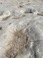
Hiking through Picketwire Canyon. Dinosaur Tracks. Photos by
Jessica Hughes.
Located in the Comanche National Grasslands, the remote and
primitive Picketwire Canyon is a rare historical site that is home to the
largest dinosaur track site in North America. Nearly 2,000 dinosaur prints in
130 separate trackways extend across a quarter-mile of bedrock along the banks
of the Purgatoire River.
Visitors can access the site by taking a hike through the
canyon for a total of 11.2 miles. The trail is relatively flat with a mild
descent into the canyon from the Withers Canyon Trailhead. There is also
camping at the trailhead.
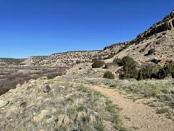
Vogel Canyon
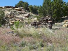
Historic ruins at Vogel Canyon. Photo by jb10okie.
When people think of the High Plains of Colorado they don’t
necessarily think of canyons. While they aren’t the deep carvings of the Grand
Canyon, places like Vogel Canyon provide much for the adventurer.
As a tributary of the Purgatoire River, Vogel Canyon is a
hot spot for a variety of wildlife. Plus, its rich history dates back 800 years
ago when American Indians lived in the canyons. View the ancient petroglyphs
along the canyon walls and the remains of an 1870s stagecoach stop.
There are four hiking trails, ranging from easy to moderate.
Plus picnic tables and restrooms.
Pawnee Buttes
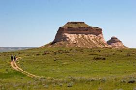
Two hikers hike to the Pawnee Buttes in eastern Colorado.
Photo by Kimon Berlin.
Another great stop for a hike is at the Pawnee Buttes Trail.
Located about 110 miles northeast of Denver, the trail is located within the
Pawnee National Grassland. The iconic Colorado landmark is two buttes that rise
300 feet above the prairie grass.
Gain an up-close perspective along the 4.1-miles out and
back trail where hikers can experience the buttes up close. In the spring,
colorful wildflowers lay the groundwork and almost year-round birders take
flight in the area’s migratory birds. Camping is allowed near the trailhead.
Picnic facilities are available as well.
Painted Mines Interpretive Park
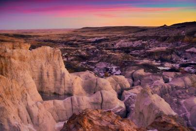
Colorful sunrise over the Paint Mines Interpretive Park.
Photo by Ryan Fonkert.
Located 30 miles east of Colorado Springs, near the town of
Calhan, is the Paint Mines Interpretive Park. This unique geological site
features hoodoos, colorful clay, and white-capped sandstone spires. Beyond its
colored walls, the area boasts a diverse ecological system with prairie,
badlands, and wetlands attracting a variety of wildlife.
There are four miles of trail at the park. The most popular
is the Paint Mines Trails, a 3.4-mile loop trail that takes visitors down into
the canyon. To help preserve this beautiful place, do not climb or walk on the
sandstone structures.