| Poly Canyon Yucca Ridge Hike |
| Poly Canyon Design Village |
| Poly Canyon West Trail Hike |
![]()
![]()
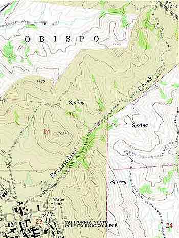
Poly Canyon is located next to the Cal Poly campus. A portion
of the canyon encompasses a 9 acre outdoor experimental construction
laboratory that's been the site of many
structures designed and built mostly by students of the College of Architecture
and Environmental Design. Click here to see Design Village Pictures.
New
To The Canyon:
The Tensile
Structure is the Design Village's newest structure. It was completed in October
2002 as three students' senior project.
Check out the field guide to Poly Canyon and more about the geological features, vegetation, history, trails and roads, and a picture gallery.
Poly Canyon - West Trail Hike is about a 3 hour hike toward the railroad tracks and returns through the Design Village.