| Hike Notes |
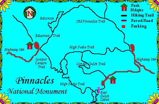
| 1st Day - East Pinnacles |
| Call ahead about cave closures due to rain, January thru March (831)389-4485 |
| Bear Gulch Caves are closed to protect a family of Townsend's Big-eared bats. |
| The Moses Spring Trail passes right above the cave and is a must. |
| An old reservoir built in 1933-4 is the return point. |
| Return on Rim Trail to where it connects with the High Peaks Trail. |
| Return to the visitor's center for Jim's cinnamon-raisin-nut bread! |
| We hiked in November and it was cloudy and cool. |
| After lunch, we hiked the Condor Gulch Trail. |
| The overlook is a good turn around point, but... |
| We had to continue to the ridge. |
| When we saw that 'signpost' we knew we'd made it to High Peaks Trail. |
| 2nd Day - West Pinnacles |
| We stayed in King City's Carriage House Inn |
| Frank & Barbara Starkey have a great B&B (See their nice website below!) |
| We dined at the Spanish Peaks Brewing Co. |
| Despite a little rain, we drove up to Soledad to Hwy 146. |
| We did the Balconies Trail and ventured into both ends of the Balconies Caves. |
| We got to see a lot of waterfalls and even a rock slide. |
| We took the Balconies Cliff Trail around the caves. |
| Hike Notes - Next Time... |
| In the spring, we'll hike the Old Pinnacles Trail to see wildflowers! |
| When it's not so wet, we can squeeze thru the Balconies Caves. |
| If the Townsend's bat will allow us, we'll see the Bear Gulch Caves. |
| There are still two hikes up to the High Peaks. |
| Once up there, one can hike across the central ridge, High Peaks Trail. |
| Geology Notes |
| Volcano 23.5 Ma, pre-San Andreas Fault |
| The Pinnacles is a collapsed caldera of that volcano. |
| Although the caldera is on the Pacific Plate, part of the volcanic mountain is south. |
| North of Palmdale on the North American Plate is the matching piece of the puzzle. |
| There the Neenach Formation matches that of the eastern part of Pinnacles. |
| If the lateral movement started about 22Ma and today, 315km separate the two locales... |
| What is the average speed of the movement in cm/yr? |
| Lecture notes from George Mason's slide show, Morro Bay Natural History Museum |
| Just throwing in a neat aerial view of the Carrizo Plain showing the offset of |
| Wallace Creek due to the S.A.Fault |